
Mapping the Future: How GIS Technology Optimizes School District Management
Imagine having a color-coded map curated just for your school district – a treasure trove of information at your fingertips, allowing you to not only say ‘X marks the spot’ but to know exactly how many ‘spots’ your school district has. Through the power of data – GIS can help school districts to regain control over their time, save money, and gain impactful knowledge about the land they own.
As school districts grow, they need to know where every easement is located. In the case of Northwest In
As school districts grow, they need to know where every easement is located. In the case of Northwest In

High-rise 101: Exploring High-rise Projects from the Ground Up
As a professional services firm, Dunaway takes pride in having a well-rounded staff with unique expertise. Through our multi-disciplines, we’ve provided services ranging from civil and survey to structural engineering on some of the most impactful high-rise buildings in Texas. In our latest insight, we reflect on some of our engineers’ most memorable high-rise projects and the challenges and solutions they encountered along the way. The Independent
Located in Austin, Texas, The Independent is
Located in Austin, Texas, The Independent is

Trend Spotlight: Increasing Urban Density in Suburban Areas
As urban areas such as Austin and the DFW Metroplex continue to attract talent and economic opportunities, smaller cities are shifting their focus to increasing population density by incorporating factors such as accessibility to work and entertainment. In our latest trend spotlight, we reflect on how smaller, suburban areas are creating dynamic mixed-use developments – hoping to attract those who want to live, work, and play there.
Located in both Johnson and Tarrant counties, Burleson is a no
Located in both Johnson and Tarrant counties, Burleson is a no
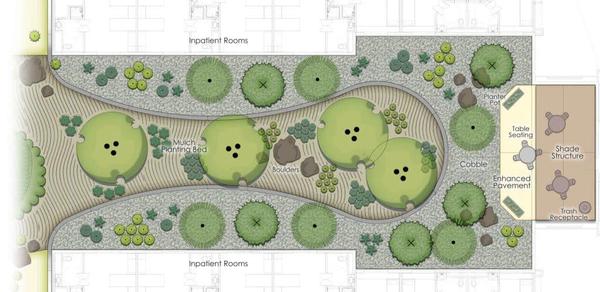
Designing for Staff Wellness: The Latest Trends in Behavioral Health Center Design
The trends we are highlighting throughout our Trend Spotlight series provide insight into how we are providing innovative solutions and memorable experiences through design. As healthcare organizations seek to increase access and meet patient demand for behavioral health, they are enlisting the help of professional design services to address aging facilities and ensure that the next generation of behavioral health centers prioritizes the well-being and comfort of patients, staff, and the communi

What Do You Weigh? | How to Lighten Up a Heavy Topic – NBGA MAG – No Basic Girls Allowed
As a12-year-old I remember impatiently waiting for the age of 13. Not because of the excitement that awaited me as a teenager, but because at 13 I could join my Mom’s gym.

Woke Charlotte York | Checking Your Privilege, One #Hashtag at a Time – NBGA MAG – No Basic Girls Allowed
Like seeing a one-night-stand the morning after – it’s difficult to view Sex and the City once you’re ‘woke.’

How to Get the Coverage Without the Cake | A Guide to Tinted Moisturizers – NBGA MAG – No Basic Girls Allowed
I live in Texas where summer means 100-degree days and 80-degree nights. It’s because of this that I’ve become a connoisseur of tinted moisturizers, BB creams, and CC creams – if it has a tint and some SPF, I’m into it. You don’t need to live in the Deep South to appreciate these formulas, though – any woman who wants a quick morning routine or an easy way to incorporate SPF can benefit from ditching the foundation and using a lighter alternative. To help get you started, I’ve compiled a list of

Top Healthy Restaurants In Houston Texas
We’ve scoured the city of Houston for the restaurants serving dishes that are as delicious as they are nutritious.
